|
ORDNANCE
SURVEY MAPS


**************
WALK
DESCRIPTION
A
10 mile circular walk from Alford to the village of Willoughby,
birthplace of famous explorer Captain John Smith. The first half
of the walk passes over flat arable land including several
cross-field paths and the second
half includes a few gentle climbs, returning to Alford via the
village of Well.
**************

BUS
SERVICE
A
number of different operators provide bus services to Alford
including Hunt's Travel, Grayscroft, Translinc and Stagecoach. For
details of public transport information in Lincolnshire, visit
the LincsBus
web site or telephone the 'Traveline' on
(0871) 2002233 between 0700 and
2100 hours daily.
**************
CAR
PARKING
A
Pay & Display car park is located just east of the town's
Market Place, next to the library. Another car park can be found
a short distance away on East Street, which at the time of
writing provides free parking.
**************
SHOPS
ON ROUTE
Alford
town centre.
**************
WEATHER
FORECAST
![[ Yahoo! Weather ]](http://us.yimg.com/i/yahootogo/ytg_weather.gif)
|
|
|
This walk
begins from the bus stop in Alford Market Place (Grid Ref: TF455759). With the Public Library
on the left, walk past the Pay & Display car park and then turn left
down Caroline Street. Follow the bend in the road to the right which
then becomes Hanby Lane. After passing the towns secondary school, the
road becomes a path which is followed to Farlesthorpe Road. Turn left
onto a roadside path and then, at the road junction, follow Farlesthorpe
Road round to the right. Follow this road for a further 125 metres.
 Turn right at a
Public Footpath sign and cross a stile. After just a
few metres, turn left over a second stile and walk straight ahead with a
dike on the left. After 2 fields, the path turns right along the field
edge for 250 metres. Turn left along
a crossfield track and follow the track, at
first right and then left. As the farm track turns sharp right, the
footpath leaves the track. Walk straight ahead, across the arable field, passing just to the right of 2 electricity poles to the
footbridge ahead. Cross Well Beck Drain and then walk ahead, slightly
right across the next field to a footbridge, aiming for a point 90% of the way
along a line of trees ahead. The next field
is crossed to a signpost approximately 60% of the way along the line of
trees. Turn right at a
Public Footpath sign and cross a stile. After just a
few metres, turn left over a second stile and walk straight ahead with a
dike on the left. After 2 fields, the path turns right along the field
edge for 250 metres. Turn left along
a crossfield track and follow the track, at
first right and then left. As the farm track turns sharp right, the
footpath leaves the track. Walk straight ahead, across the arable field, passing just to the right of 2 electricity poles to the
footbridge ahead. Cross Well Beck Drain and then walk ahead, slightly
right across the next field to a footbridge, aiming for a point 90% of the way
along a line of trees ahead. The next field
is crossed to a signpost approximately 60% of the way along the line of
trees.
 Ascend an incline on to the course of an old railway line which
previously ran from Willoughby to Sutton on Sea, Mablethorpe and beyond.
This section of the line has now been turned into a nature reserve run
by the Lincolnshire Wildlife Trust. Turn right and follow the trackbed to the south-west.
Ignore the footpath 150 metres ahead on the left. As we
walk along, views of Willoughby church can be seen on the left, through
gaps in the bushes. When the nature reserve ends, join a new path
heading east along the southern edge of a dyke. Upon
entering a second field take an immediate right along the fieldedge and follow
the footpath to Station Road in Willoughby. Before continuing on
the footpath opposite, it is worth making a visit to the Village Green
and church. Ascend an incline on to the course of an old railway line which
previously ran from Willoughby to Sutton on Sea, Mablethorpe and beyond.
This section of the line has now been turned into a nature reserve run
by the Lincolnshire Wildlife Trust. Turn right and follow the trackbed to the south-west.
Ignore the footpath 150 metres ahead on the left. As we
walk along, views of Willoughby church can be seen on the left, through
gaps in the bushes. When the nature reserve ends, join a new path
heading east along the southern edge of a dyke. Upon
entering a second field take an immediate right along the fieldedge and follow
the footpath to Station Road in Willoughby. Before continuing on
the footpath opposite, it is worth making a visit to the Village Green
and church.
 Turn left along
Station Road and follow a roadside path until the road bends sharp right
to arrive at the north-western corner of the Village Green. Follow the
edge of the Village Green towards the
church, pass through a gate and over a track. Keeping
to the right hand side of the next field pass through the gate ahead between 2
bungalows and exit onto Church Lane. Turn
right and after just a short distance, left into the churchyard. of St
Helena. Willoughby is the birthplace of famous explorer Captain John
Smith and the church contains some fine stain glass windows depicting
his life. Exit the
churchyard and walk west along the road to arrive back at the Village
Green. Turn right on to the Green and use the benches to take a break.
Walk back to the north-west corner of the Village Green and retrace
steps along Station Road. Turn left along
Station Road and follow a roadside path until the road bends sharp right
to arrive at the north-western corner of the Village Green. Follow the
edge of the Village Green towards the
church, pass through a gate and over a track. Keeping
to the right hand side of the next field pass through the gate ahead between 2
bungalows and exit onto Church Lane. Turn
right and after just a short distance, left into the churchyard. of St
Helena. Willoughby is the birthplace of famous explorer Captain John
Smith and the church contains some fine stain glass windows depicting
his life. Exit the
churchyard and walk west along the road to arrive back at the Village
Green. Turn right on to the Green and use the benches to take a break.
Walk back to the north-west corner of the Village Green and retrace
steps along Station Road.
 Turn
left on to a footpath opposite the one which came from Alford. Walking
to the left of the village allotments, follow for 200 metres, pass
through a gate and then
turn right. Exercise extreme caution when crossing the
Clover Industrial Estate being aware of any forklift trucks in the
vicinity. Cross the next 2 fields to reach Hoplands Wood, another nature
reserve. This woodland provides the option to complete an additional 1
km waymarked circular route. Exit the woodland over a footbridge and then
walk across the next field aiming for a position to the left of the
woodland ahead. Turn
left on to a footpath opposite the one which came from Alford. Walking
to the left of the village allotments, follow for 200 metres, pass
through a gate and then
turn right. Exercise extreme caution when crossing the
Clover Industrial Estate being aware of any forklift trucks in the
vicinity. Cross the next 2 fields to reach Hoplands Wood, another nature
reserve. This woodland provides the option to complete an additional 1
km waymarked circular route. Exit the woodland over a footbridge and then
walk across the next field aiming for a position to the left of the
woodland ahead.
 Cross a
footbridge over a flowing stream and then turn right onto a track.
Follow the edge of the woodland and at the second corner we leave the
track as it turns sharp left. Pass through a gate and walk parallel with
the woodland and climb the steep hill to the fieldgate visible ahead. Exit the
field, cross the road and turn left along the road. Just 50 metres ahead
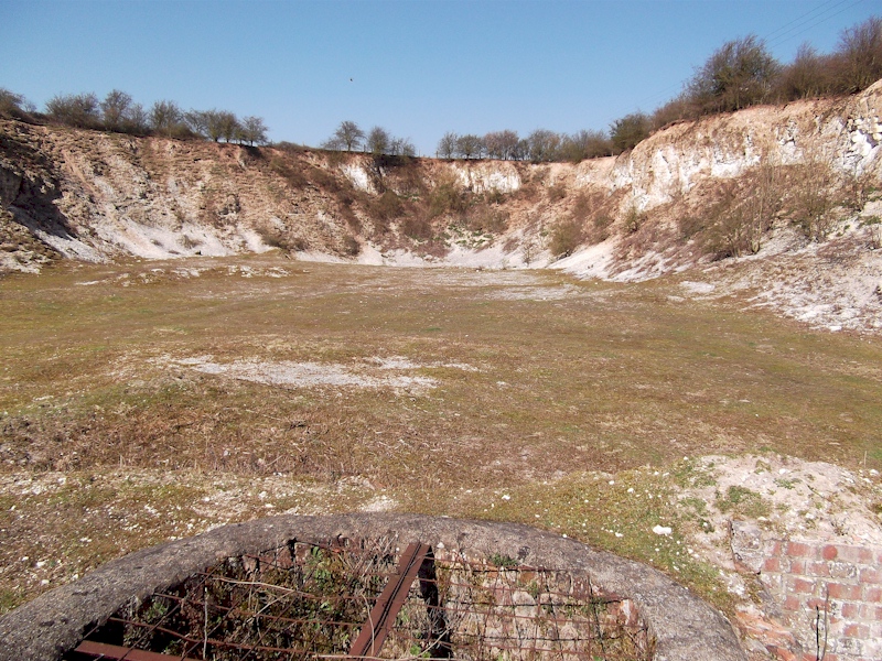
is the entrance to Mill Hill nature reserve and former quarry. From the
gate, the impressive quarry face can be seen. The reserve is normally
open to the public and if time permits is worth a visit. During April
part of the reserve is covered with wild primroses. Cross a
footbridge over a flowing stream and then turn right onto a track.
Follow the edge of the woodland and at the second corner we leave the
track as it turns sharp left. Pass through a gate and walk parallel with
the woodland and climb the steep hill to the fieldgate visible ahead. Exit the
field, cross the road and turn left along the road. Just 50 metres ahead
is the entrance to Mill Hill nature reserve and former quarry. From the
gate, the impressive quarry face can be seen. The reserve is normally
open to the public and if time permits is worth a visit. During April
part of the reserve is covered with wild primroses.
Page 1 of 2
|